Thursday, 6 March 2014

IML winter assessment - Top Tips

Having just completed the final stage of my International Mountain Leader Assessment - the WInter assessment - I thought it might be worthwhile sharing my experience and in particular the nature of the assessment for those gearing up for next year or just contemplating IML.

I have listed the daily schedule at the end, no specific locations mentioned so hopefully Carlo Forte (PyB) won't be too perturbed:-)

Many of the comments I made in my blog last year about Winter ML  (click here to read) apply equally here, but there are some obvious (and less obvious) differences. Here is a summary of the key points with the weeks schedule listed at the end.
  • The whole assessment is done on snowshoes, there is no use of crampons.
  • Snowshoeing often uses ski locations and lift systems to gain height so management and safety of your group in these environments is important.
  • The emphasis on group management is just as strong but it goes further, to group engagement.  So you need to ensure your group are not only safe, but kept interested in things like fauna, flora, local area, history, legends ( my personal fave) etc. whilst navigating and ensuring the terrain is safe.

So whose tracks are these?
..and these?
  • Navigation: The reality of snowshoeing with clients is probably on easily navigable routes, but this is taken further for assessment, so there is some micro nav to contour features off the paths/tracks. Despite having managed pretty well on WML last year I actually found this quite hard; nav'ing in forest on slopes with lots of small contour features proved challenging - especially relocation - and this was much more strongly emphasised than on summer assessment.  You do, of course, have to be comfortable with the French IGN 1:25k maps.
  • Avalanche awareness and snowpack understanding is at a higher level than WML and use of transceivers to search for buried people is a significant part of the assessment.  We had to locate one person in 2 mins and two people in 8 mins.  Daily Transceiver checks and basic teaching also feature.  I had some issues with the transceivers I bought via the BAIML trade deal which undermined my confidence in this area somewhat, so do your research beforehand, take advice from fellow IMLers and don't always assume cheap trade deals=best option!  Make sure you are well practiced and happy with your chosen product before assessment.
  • There is no overnight expedition as such, each day returns to base and a nice meal and comfy bed.  The days out are also not desperately long, but this does not mean it is easy! Every evening except the final one includes additional tasks such as route planning, weather/avalanche assessment, a test and so on.  It all feels pretty intense with little downtime.
  • If you've done WInter ML or at least scottish winter skills, the ropework should hold no fears for you and you may be able to use trees at times, but they will want to see some snow anchors.  These can be more wide ranging than WML (probably due to the nature of the snowpack?) so its not unusual to back a bucket up with snowshoes,rucksack, ski poles etc.  If you haven't done WML then this will need quite a bit of practice to make it work and look good.
  • The assessors are not trying to fail you and will give you a chance over the week to improve on areas that weren't as good as they could have been.  The week also includes a significant element of new learning, which is good in my book.
  • Unlike scottish winter, there is quite often sunshine and you can see things!

Our schedule:

Day 1: 
Trannsceiver checks 
Navigation in mountainous wooded area
Environmental knowledge 
Snow pit analysis 
Long distance peak identification 
Looking after group on snowshoes in wooded steep terrain 
Evening journey planning - group exercise 
Evening avalanche/snow test
Day 2: 
More navigation on forested slopes, increased emphasis on micro 
navigation 
More enviro & local area knowledge 
Group management 
More snow pit analysis 
Single transceiver search 
Delivery of a prepared talk 
Evening journey planning - group exercise
Day 3: 
Change of assessor. 
Longer day round lakes with more navigation and group 
management 
Transceiver checks 
Single transceiver search 
Ropework and security on steep ground 
Emergency snow shelter 
Frozen lakes issues and safety 
Evening journey planning - individual exercise
Day 4: 
Further navigation & group management 
Snow anchor based ropework 
Single & multiple transceiver search 
Snowpack analysis & shear tests 
Delivery of a second prepared talk
Day 5: (half day) 
Minimal navigation 
More in-depth snowpack analysis / learning 
Multiple transceiver search 
Large burial (6) / large group transceiver search 
Delivery of result and final debriefs

Hopefully, it goes well, you pass and then you are allowed to wear and use one of these beauties:-)


Hopefully this sheds some light on the winter assessment and maybe on the IML as a whole.

Finally, a quick thanks and shout out to my fellow assessees and the assessors Carlo, Karl and Steve, for their help and support.  Looking back it was a great week, though I wasn't sure whilst in the middle of it!

Thanks for reading.
Andy Dawson.

Thursday, 5 December 2013

Nepal Trip 2013 - stage 1 Gokyo

This is the 1st of a few blogs on Nepal - originally intended to be written out there, but lack of signal and poor technology choices on my part scuppered that one!  

This blog covers the first stage of a long break, a 2 week trek upto and back from, Gokyo. My wife was with me for this stage only, hence the return to Lukla.  As well as being a record of our stay, it may provide potential visitors with some useful background information. Subsequent stages include some solo trekking over the high passess of the Khumbu and an attempt on Ama Dablam, unsuccessful due to an accident caused by rope breaking on an abseil descent - more on the that to come. 

I'm also planning to put up a trekking kit list ranked by what I used and what I actually found useful.

The bulk of pictures from this stage are collected in a youtube video, so I haven't repeated them here.  This is the same one as posted on my website and facebook page so you can save yourself the pleasure of a repeat if you've seen it :-)

For those who want to see the pics they are:  http://youtu.be/m0yNqbj4-IY

For those who haven't been, there is description of a lodge at the end.

Nepal Stage 1:Kathmandu - Lukla-Namche-Gokyo-Namche-Lukla-Kathmandu


Day 1: Kathmandu (c. 1500m) - noisy, dusty, dirty.
Like most developing world cities a shocking mixture of modern and old, wealth & abject poverty. Overall a very busy, very dirty city which may have been quite special a few hundred years ago!

Day 2: flight to Lukla, walk to Benkar
A chaotic check in at KTM airport (really glad we had an agent here) followed by a really cool half hour flight on a 16 seat Dornier STOL plane  and first view of the mountains!
Then an exciting landing at Lukla's very short airstrip - even these STOL planes have to do a sharp right at the end to avoid the wall.

Short walk over to Paradise Lodge for a hearty breakfast, finalise kit leaving arrangements with the owner and hire a porter. Finally started on our trek!

We aimed to get to Phakding at least  and if all well continue on towards Monjo. Despite the number of people on the trail (a lot) we started to enjoy it immediately. Lots of new sights and then our first suspension bridge over the Dudh Khosi! Despite a leisurely pace and a coffee stop we made Phakding in good time and after a hearty lunch decided to carry on.  

The fascinating thing about this trail is that from Lukla, there is no transport other than by foot.  Admittedly, some of the feet aren’t human – as in they are donkey, horse, Dzopkio or Yak - but there is nothing motorised or wheel based , no cars, jeeps, tractors, bikes. There are helicopters, but they are primarily for emergency and transport very little of the region’s provisions or people.

With afternoon drawing on and tiredness setting in we came across a charming lodge at Benkar called Waterfall View Lodge - aptly named for the waterfall right next to it - and decided to call it a day.   After settling in and a cosy few hours wrapped in a blanket in the main room and dinner, we decided to call it a day and went to bed - at 7.30pm!

Day 3: Benkar - Namche Bazaar (3400m)
The extra 2 hours gained the previous day meant we could have a relatively leisurely start, but our porter looked horrified when we suggest an 8am breakfast, so we settled on 7.30am and were underway before 8.30.

The day followed a similar pattern to yesterday to begin with; leisurely, undulating walking and a number of suspension bridges before lunch. Afternoon brought the steep climb up to Namche which included a very high suspension bridge and our first view of Everest and Lohtse.   It was a much better view than expected and we both felt quite emotional.   


We arrived mid afternoon and were ushered into the Kamel Lodge by our porter who seemed very keen we stay there - I'm sure they have some arrangement going with lodge owners.   Still, after a brief check it seemed a reasonable place, so we decided to stay. After lemon tea and getting gear sorted, we hot footed it to the Everest Bakery for a very pleasant cappuccino, apple pie and wifi - not very wilderness but nice!

Namche is clearly geared up for the trekking tourist trade but manages to retain its charm. The buildings are fairly traditional Sherpa stone buildings even if the billboards and tin roofs aren't! The narrow cobbled/mud streets are frequently blocked by Dzopio trains and random Dzopio cows and calves wander the streets at will. The place is pretty clean - much more so than KTM - and the Sherpa people are infectiously friendly and smiley. Their English is superb and it's common to get very small, incredibly cute children engaging you in conversation, English now being the main teaching language. There is electricity most of the time and better mobile reception than I get at my house!

Day 4: Namche based, walk to Everest View Hotel
A Steep uphill hike, round a corner led to an unexpected and amazing view of the mountains! Everest, Lohtse, Nuptse were clear to see but the view was dominated by the beautiful and solitary form of Ama Dablam. A slightly strenuous onward walk to the hotel followed, where we sat on the terrace drinking tea and eating cake, whilst staring at probably the best cafe view in the world!

After a nice chat with an Australian couple we walked back down to a later than ideal lunch at another cafe/bakery, before back up the lodge for a hot chocolate and sleep before dinner.

Day5: Namche to Dole (4040m)
This is a big day and we were a bit concerned about how we would do. In the end it was a superb trekking day.  The first half is fairly undulating, under the shadow of AD and Everest until turning off the main Everest Base Camp trail at Sanasa onto a much quieter and steeply rising trail to Mong-La before an equally steep descent to Phortse Tenga (PT).   On the rising section we were lucky to spot a herd of Tahr (native mountain goats) and a large raptor circling overhead - not sure if it was a  Griffon Vulture or a Lammergeier but we aren't fussy!  

After lunch at PT we started the steep, long drag up to Dole. Despite the steepness in places, this is a lovely section incorporating rhododendron forest and numerous waterfalls, where we were lucky to see a couple of Musk Deer including a male with his characteristic fangs. Beyond the forest, the area opens out to reveal a superb vista of waterfalls and snow peaks above, with steep river valley below. Sooner than expected we reached Dole and chose the Himalayan Lodge,  a traditional looking but fairly new lodge and bagged the last twin room – result!

Dole is small but very pleasant, spanning a stream and small valley, which provides trees and interesting vegetation to complement the Yak enclosures.

Day 6: Dole to Machermo (4410m)
This is a relatively short day but with 400m of height gain and another 400m to the next village - our destination of Gokyo - Machermo is the obvious and sensible choice. 

We awoke to a fairly heavy frost but with morning sun, it had melted by the time we set off at 8:30. The day began with a stiff climb out of the side valley onto the main valley side and then a more reasonable rising traverse in lovely sunshine towards Luza. We were both feeling the altitude a bit more but still moving faster than most and this section was illuminated by our first Eidelweiss and then the magnificent 8000m peak of Cho Oyo came into view, dominating the head wall at the end of the valley.  

By the time we dropped down to Luza after a shade over 2 hours, we were more than ready for a stop and a reviving hot chocolate basking in the sun.  Reluctantly, we got moving again with another stiff little climb back onto the valley side, hitting snow for the first time – unusual for this section of trail, but the typhoon about 10 days previously had left its mark in Nepal as well as India. From then on a mixture of mud and slush made the going slightly slippy and we were glad to make Machermo at around 11.30am, check into the very pleasant Namgyal Lodge and order a delicious lunch of Tibetan bread and vegetable momos - a kind of Tibetan dumpling. 

Following an afternoon nap I headed over to the medical post at 3pm for a talk on altitude illnesses and porter protection. During the talk I had my blood saturation measured at 90% - not bad considering our rate of ascent. After more chilling out back at the lodge and a few rounds of cards it was time for dinner - a delicious curry - and this blog update!

Machermo was heavily snow covered when we were there, making it difficult to assess what it would be like normally.  It is split by another stream, but unlike Dole has no other vegetation and came across as a little bleak, albeit with some superb views.

Day 7: Machermo to Gokyo (4800m)
Another fairly short day with around 400m height gain with a guidebook time of 3hrs.  The day started with another stiff little climb and then straight into the snowline and an exposed rising traverse until we met the narrow ablation valley at the very upper end of the river.   From then on an increasingly steep climb along the side of the valley wall on a decent, but in places icey, path saw us using our Kahtoola spikes for the first time. From here on, congestion with slow moving organised groups became quite a problem.  As we got higher, we observed an interesting phenomenon in the river - two separate streams flowing down from twin sources, one straight from the glacier was a milky white with glacial debris, whilst the right hand stream flowing from the first lake was clear, the two streams joined and mingled only slowly.  Shortly afterwards we reached the first lake,  took our chance to pass most of the slow moving snake and settled into our own pace once more up to the much more spectacular second lake.  Here, we had the obligatory photo shoots before plodding on tiredly to the third lake and our destination, Gokyo. We crested the outflow moraine and were treated to a breathtaking sight - an azure blue lake nestled in a bowl below some magnificent rocky, snowy spires and Gokyo village nestled just above the shoreline.  As we entered the village I spotted a guide/porter we had met en route and asked for a recommendation.  He instantly replied 'Gokyo Lodge' and nipped off to get us the last room available - a really nice gesture especially as it was a superb little twin overlooking the lake and catching the lunchtime sun. After a very pleasant lunch, we sunbathed and drank in the view for a while, then feeling exhausted had an afternoon kip before dinner - a very nice Spag Bol!   Post dinner we sat and chatted with some fellow guests and played cards until the heat of the stove and tiredness drove us to bed fairly early - big day for me tomorrow climbing Gokyo Ri, a height of 5330m and my first time over 5000m.

Day 8: Gokyo (4800m) + Gokyo Ri (5330m)
Today was an acclimatisation/rest day after gaining over 1000m in height since Namche, but with the walk up Gokyo Ri, with its famed views of Everest, Lohtse, Makalu, Cho Oyo as an activity for me.

I decided to test myself a bit by trying to set a reasonable pace and keep going all the way if possible. The guide book time is 1.25 - 3 hrs to the summit and I hoped to get somewhere near the fast time.  I set off fairly steadily at 8:30 am exactly and found a good rhythm with hard but controlled breathing,  though I quickly found was overdressed, so stopped after about 5 mins to strip a layer. From then on it was non-stop to the top, my rhythm only interrupted when catching up slower moving groups. I didn't look at my watch again until the top - 9:18am a total time of 48 mins ... I was amazed! I'm clearly in reasonable shape and fairly well adapted at this altitude which bodes well for Ama Dablam.

I then concentrated for the next 40 mins on the breathtaking views from this viewpoint, becoming quite emotional as I looked at the north col of Everest and Mallory's 1924 route above it.  Mallory is a climbing hero of mine and I found myself hoping more fervently than ever that he did make it, even though he didn't live to tell the tale. I have no issues with Hillary/Tenzing being the first ascensionists - to my mind you have to come back to claim a successful ascent - but it would be a fitting tribute to a climber ahead of his time and obsessed with Everest, if it were ever proven that he stood on the summit.

Back to the present, mission accomplished I wandered back down in more relaxed fashion, staying clear of the main track to enjoy the snow and meeting Julie at the bottom. We then settled down to a relaxed day of drinking coffee and eating, which was slightly interrupted when I discovered that there is a leaders ladder for the ascent of Gokyo Ri and the lead time is 46:25! Being the competitive soul I am, I immediately started pondering 'what ifs' - if I'd known there was a leader board, if I had started 'cool', eliminating the layer stop, etc. Maybe I'd have got close to, or beaten that time. I reckon I could have but I'm not going back to try again!  We spent a very good afternoon sunbathing and buying some artwork from the 'Highest art gallery in the World'  but it was clear that potential weather changes could be on the way as high cloud moved in and took away the heat of the sun. We retreated inside to play cards and write this blog. Tomorrow we aim to leave by 7:15am and get as far back down the valley as we can, ideally to Kyanjuma, so long as the weather doesn't have other ideas!

Day 9: Gokyo – Kyanjuma
We knew we had set an ambitious target and so it proved, although overall we had a very enjoyable day. We saw quite a few more EIdelweiss – more than I have ever seen in Europe – and spent quite a while watching Musk Deer and Danphe (the National bird of Nepal) and enjoyed a couple of coffee/lunch stops.  The long climb up from Phortse Tenga to Mong-La was tough though and by the time we had descended back to Kyanjuma it was getting dusk.  I sent our porter, Dawa on ahead of us from Mong-La to ensure we got in a lodge somewhere.  I had hoped for the Ama Dablam Lodge but it was full.  In the end, we had a newly built lodge all to ourselves complete with our own brand new toilet, though still with the usual bucket flush.  The view we encountered in the morning at breakfast was superb, with Ama Dablam dominating the near skyline and pine trees adding some colour and differentiation.

Day 10: Kyanjuma – Jorsale
The reward for yesterdays’ haul was a fairly mild day, nearly all descent and the chance to chill for a while in Namche - cue Everest Bakery and coffee shop again! We had a recommendation for the evenings lodge, the Nirvana Lodge at Jorsale -  just after the suspension bridge which follows the descent – so we sent Dawa on ahead to reserve a room and lingered quite a while, before taking the old trail down as far as Top Danda.  This was narrower, but still good and very quiet.  We arrived at the suspension bridge as the shadows lengthened and met our trusty porter waiting for us at the far end.  The lodge, looking a little like an English country cottage, was superb, overall the nicest one we stayed at.

Day 11: Jorsale – Lukla
Pretty much a repeat of our first trekking day.  This time with the climb back to Lukla at the end, but with better acclimatised lungs!  It felt a long day, though I think some of this was down to the flat feeling of knowing it was almost over. We arrived at the Paradise Lodge mid afternoon to discover that many flights had been cancelled and that some people were backlogged 3 days!  We hoped Julie would get out OK and took comfort from the fact that our agents, Himalayan Guides, use the Paradise Lodge owners as part of their team.  The owner worked with Hillary to build the runway he and his son also run the airport terminal :-)  We settled down and enjoyed our last evening together with a sizzling steak and a glass of wine!

Day12: Lukla – Kathmandu (Julie)

Well we were lucky, Julie’s flight was first thing and she made it as one of only 6 flights out that day. It was a sad little parting after such an amazing 10 days and she now has time to spend in KTM before heading home whilst I have a rest/wash day here before setting off on stage 2 – the Rhenjo-La (via Thame) and Cho-La before meeting my Ama Dablam team for stage 3.


Useful info:
A lodge/tea-house typically comprises a granite stone building with tin roof.  It usually has a shared room where everybody gathers, socialises and eats. There is a stove which burns wood and (higher up) yak dung and there may have blankets to wrap up in. The rooms seem to be mainly twin rooms these days rather than old style dorms, with a pillow and blankets - you will need a sleeping bag and ideally a pillow case.  The rooms have no heating and very thin plywood walls, so they can be cold and if your neighbour snores, noisy.  Toilets are shared (except for few lodges where you pay a premium for a private loo) and are often 'french' style (ie a hole!) although there were more 'sit on' toilets than we expected and often lodges had both.  In the majority of case there is no flush (or it doesn't work due to the cold) but this is overcome by means of a large container of water ( which occasionally freezes overnight) and a bucket. Overall the toilets are primitive by western standards but better than we expected.  Costs for a room are very cheap c. NR200 or $2 so long as you eat breakfast and dinner there.  Food is more expensive, with a pot of tea costing more than a room for the night, but overall $30-35 a day for food and lodging is quite achievable.  

There a loads of them between Lukla and Namche so deciding as you go is quite easy.  In the higher areas, they are generally clustered in small remote villages once off the EBC trail, but seem to be on the increase (certainly more than in our guidebook).  As a single or couple you will generally be OK to turn up on spec  - we were -  but larger groups should definitely look at booking in advance.

Thursday, 12 September 2013

Valais Alps Extravaganza

The following is an account of an amazing week mountaineering in the Valais Alps this August, with my climbing buddy Giles Ruck, which included:
  • 12 4000m+ tops.
  • 7 major 4000m peaks: Breithorn, Castor, Lyskamm, Pyramide Vincent, Signalkuppe, Dufourspitz and Nordend.
  • 3 classic AD routes.
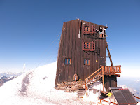
  • 5 nights sleeping at, or above, 3400m and one night at 4500m in the highest building in Europe.
For an extended set of pics on flickr, please go to the end of the article for the link.

PS If you didn't come here via my facebook page perhaps you could like it now:

Day 1 (Saturday):
Fly to Geneva, train to Aigle, picked up by Giles who had finished his IML summer assessment a few hours earlier.  Drive to Stalden, find a motel, eat,  sleep!
Day 2 (Sunday):
The morning consisted of Breakfast, faffing with kit, drive to the local station, more faffing to find a place to leave car, train to Zermatt, a milk float across town to the Klein Matterhorn cable car, up the cable car, a bit more kit faffing and finally ready to start on the Breithorn at about 1pm!
We enjoyed a quick romp up the Breithorn, which was very easy despite quite soft snow and a small river at one point and best of all no altitude effects.  We then descended and made our way round to the Val d’Ayas hut.

No sooner had we arrived at the hut, than we bumped into 2 IFMGA Guides I know from my home area – Phil Dowthwaite and Owain Jones, affectionately known (by themselves!) as the Morecambe Massif; both doing the ‘spaghetti Tour’ with a group of english clients, two of whom were also from the Chester area – it never ceases to amaze me what a small world this is!  We were then in the same huts as these guys each night which made for a nice social side to the trip.

The Val d’Ayas was a nice traditional hut, though busy, with small dorm rooms and our own bunk beds.  The  only down side to the hut being the continental style, hole in the floor, toilets.
Day 3 (Monday):
Woke to poor visibility with some people getting up just after 4 am despite a short day on offer!
We luxuriated a bit longer in bed and had a very leisurely breakfast and faff time, meaning we were just about the last to leave by some margin.  Despite that, by the time we started up the flank of Castor we had overtaken most people and overhauled our Brit-Guide buddies on the ascent itself thanks to their being very accommodating in letting us through.  We met on the summit again and Owain gave us very helpful info to assist our navigation down the other side in what was now typical Scottish winter conditions i.e. very poor visibility! We romped down the other side and were in the Quintino Sella hut before lunchtime – great for eating and a bit of rest, bad for boredom and wanting to get on with it!

We really wanted to do the Lyskamm traverse the next day but with fresh snow forecast overnight and the likelihood of strong winds it just wasn’t on.  None of the guides were risking it, so there was no way we were going to try. We looked at the guidebook and decided that we would have a go at the South ridge of Lyskamm if the weather wasn’t too bad as it is mainly a rock ridge with the option of coming back down it if the snow was bad on top. So, satisfied we would have a crack at Lyskamm, we went to bed with the snow coming down outside.
Day 4 (Tuesday):
The early morning was not promising, some fresh snow lying around, cloud lingering and a strong wind still blowing but we kept the faith in the forecast which had promised the wind would abate.  To that end, we had another leisurely start and once again caught up to most people by the time we needed to start the ascent of Il Naso – a stepping stone for us, but the main event for most people on the hill.  A queue had formed on the steep direct route, so we chose to follow the alternative rising traverse which we spied a few people taking. As we progressed, we could see the two teams in front of us stopped and apparently unwilling/unable to go further on the traverse line.  On approaching, it appeared that there was a very icy section and no-one fancied it.  

After some deliberation, Giles and I decided to dispense with the traverse (and the issues of trying to get round people) and take route 1 - a direct line up the icy slope to the crest.  I placed a screw and Giles clipped onto it and belayed me as I set off up a section of hard ice at around 55O.  The crampons and my technical axe bit well but the mountaineering axe took a bit of whacking to get a firm placement and I found my first ice climbing experience at 4000m a pretty tiring one!  After about 30m, the ice was becoming more nevé like, so I placed a belay screw and brought Giles up to lead on through. About 15m further up he reported easier going on good nevé, so we took the decision to carry on together.  I stripped the belay and we progressed fairly quickly but breathlessly to an easing of the slope near the summit plateau, whereupon we stood gasping until recovered enough to walk up and onto the summit, passing our Brit-friends just coming back off it.  Our proximity to them told us that our decision to take an alternative route was justified as we had leapfrogged another few crews. 


At this stage, our route took us on over the summit and down a steep and narrow rock/snow edge to the snow col at the bottom of our route, the Cresta Sella or South Ridge. The col was a short but narrow snow arête followed by a short section of mixed before what looked like clear, dry rock for the majority of the ridge until just the junction with the East Ridge.  We decided to dispense with crampons –a good move in the conditions – and made steady progress upwards through a series of steps which at first looked intimidating but always provided a steady route.  The guide book indicated that steps should be taken on the left but we took a variety of routes sometimes left, sometimes right, sometimes direct.  The rock quality deteriorated quickly away from the crest so we tried to stay close to it whenever possible, also using crampon scratches as a guide to the most used route. 

As we approached the top we had a short section of steep snow/ice and a small cornice to negotiate so crampons went back on at this stage and Giles led on over the edge and onto the E ridge where a left turn up the snow arête (quite broad at this point) to a narrow section and a final rock step brought us onto the summit and real sense of satisfaction – we had done this on our own, the only people to take on the challenge that day and had the summit to ourselves as we pondered the next decision – which way down?


To retrace our steps was doable, if much less pleasant than the ascent, and indeed the guide states this is the safest way off the mountain in poor conditions and would take quite a while once the descent of Il Naso was factored in. The alternative was to descend the classic and (in)famous E ridge snow arête. The guide describes it as “... a sensational knife edge ... good balance and steady nerves are essential”!  We looked at it and decided it was in reasonable condition and that we should give it a go – we also had the knowledge that a couple of people had successfully completed it that day because we had seen them from the Cresta Sella.  

After a gentle start, the ridge lives up to its reputation, being as wide as a gymnastics beam in places and requiring several steps from one side of the crest to the other and a very short section requiring side stepping on steep, softish snow. However it does relent slightly in between the trickiest bits and I actually started to enjoy it -whilst still wanting it to end!  It took us an hour to gain the Lisjoch - the col at the start/end of the ridge – well under guidebook time of 1.5-2hr and much faster than the descent of the Cresta Sella would have been. Even better, we now had only about an hour of easy snow plodding to reach the Gnifetti hut (which we did in less) and still overtook parties who had taken the standard Il Naso route on the final approaches, arriving in time to get a late lunch and bask in the cosy glow of satisfaction that comes from one of those days where everything – weather, decision making, movement -  all clicks to make a memorable outing.


The Gnifetti hut proved to be another solid hut with small dorms and decent food (the usual hole toilet unfortunately) and we enjoyed a pleasant, but tired, evening.
Day 5 (Wednesday):
After a very poor sleep, we settled into our usual relaxed morning hut routine as a beautiful day dawned with super cloud inversions. This day was set to be a day of peak bagging, all fairly easy technically, but with a lot of ascent culminating in the Margherita hut at 4500m on top of Signalkuppe.  The route is known as the ‘traverse of the tops’ but we were also adding Pyramide Vincent (an independent 4000m peak) to the agenda.  Within 10 minutes of starting the slog up the glacier I could tell I was jaded for the first time on the trip and that this was going to be a long, tough day. Even so, we still moved faster than everyone else as we peeled off to get to the col for the final ascent slopes up Vincent.  Gaining the col, we were rewarded by some amazing, picture postcard views of the hills on the Italian side in the early morning mists and cloud.  Vincent was despatched easily enough and we luxuriated on the summit in the sunshine just drinking in the breathtaking scenery before forcing ourselves to move on and down to the col, thence rejoining the ‘traverse’ trail and completing the Balmenhorn - not really a top but it does have a bivi hut and a statue of Jesus on its rocky top so worth a visit - Corno Nero, Ludwigshohe, a snow arête traverse of Parrotspitze which I found particularly hard going on the uphill stretch due to my tiredness and finally the long slog up to the summit of Signalkuppe and the hut.  Despite my tiredness, I was satisfied to see that we were coping with the altitude better than most, keeping up a steady plod whilst most parties were in that start/stop mode of people unable to get enough breath to keep going. 

The Margherita hut is quite an edifice, perched on the summit of Signalkuppe, the 4th highest summit in the Alps, with room for 80 people - all of whom can be fed a 3 course meal in the evening!  There is no water there except bottled water and in the toilets (yes you guessed it – more holes) I learnt one possible origin of the phase “shitty stick”!  There were quite a few people here struggling a little with the altitude but no-one I saw developing full blown AMS.  Surprisingly, even at this height we had individual bunk beds rather than the classic alpine platform.  Separate beds seem to be bit of a feature of Italian huts, which I like.  The views at sunset from here simply defy description!


Day 6 (Thursday):
Despite the altitude I had a better sleep, which was just as well because this was to be our biggest day yet, hopefully bagging the Dufourspitze the crowning glory of the Monte Rosa massif and second highest peak in the Alps at 4634m and finishing with Nordend(4609m) the third highest. 

The day started with the short, steep descent to the col below the hut, followed by a traverse of Zumsteinspitze, a subsidiary peak. This involved a fairly straightforward ascent but a very scary snow arête down the north side!  

This was, if anything, narrower than the E ridge of Liskamm and steeper at its crux but thankfully this was short.  There then followed a tricky mixed descent to the  col of the Grenzsattel.  One move in particular, the final one before gaining the snow arête of the col, involved lowering over an overhang in hope and anticipation that there would be something for my feet as I got lower, which fortunately there was!  This was followed by more snow arête, rising this time which I find much easier, before arriving at the base of our main objective – the SE ridge.

This involved some superb mixed climb up the crest of the ridge to the Grenzgipfel, with a slabby section in the middle – we had heard this was a bit tricky and poorly protected but in the event I found it straightforward and great fun.  

The final section from the Grenzgipfel to the summit  involved a tricky traverse to summit  - mainly due to a couple of tricky downclimbs with much air beneath them – passing the descent route with its rope, on the way, but finally we had made it, the high point of the whole expedition, in amazing conditions.  Whilst relaxing at the summit a voice near me suddenly said “Is that Andy?” and I turned to see Dave Kenyon, a British Mountain Guide, with whom I have done some routes, with a group from Martin Moran, and as we spoke another head popped over and it was Andy Teasdale just summiting with another client from Martin –and as we chatted and drank and ate a little on the summit it felt almost like a Brits tea party!  It transpired that they were also going to summit Nordend before descending back to the Monte Rosa hut – a very long day for them as ascent of Dufour alone is around 8hr from the Monte Rosa hut.

So, in a bit of a line we made our descent via rope to Silbersattel, completed the snow arête and rock step ascent of Nordend our final peak before starting the long descent via crevassed glaciers and loose rock to Monte Rosa hut, the latter part of which was fairly unpleasant in our tired state of mind.  

Once at the hut we tucked into a celebration lunch of Rosti and Rivella, whilst steeling ourselves for long dash out to get the Gornergratt train to Zermatt.  If we thought the fun and trickery were over however, we were forced to re-appraise as we crossed a horribly crevassed dry glacier, ascended long ladders, rickety bridges and completed a final uphill route march to gain the station with 15 mins to spare - phew!

From then on, things finally quietened down and we gradually made our way down the valley, collected the car and Giles manfully drove us back to Chamonix and our bed for the night in his father-in-law’s chalet.

Extendecpicture set here:
http://www.flickr.com/photos/shandyd05/sets/72157635363612918/

Thursday, 15 August 2013

IML Summer assessment

Things have been a quiet on the blog front for a while, mainly due to the fact that we have been away for nearly 4 weeks in the Swiss Alps!

The prime reason for the trip was to attend and hopefully pass my International Mountain Leader (IML) summer assessment.  This is still a developing award but the standard is getting higher, more people are now requiring it of their Mountain Leaders and in much of Europe it is, directly or indirectly, compulsory.

As a bit of background, the IML is one of only two internationally recognised mountain qualifications; the other being IFMGA Mountain Guide (these latter being the god like characters who take people on top of big mountains in the Alps etc.).  IML qualifies holders to take people in the mountains where technical skills of climbing and via ferrata are not expected and where glaciers are not involved. However, short sections of fixed gear protection are within remit, as is snow and winter trips on 'nordic type terrain', mainly targeted at snowshoeing. The award is quite difficult (and expensive) to attain, requiring an entry qualification of Summer ML and requisite foreign experience, followed by a summer training course, navigation speed test, winter training course, summer assessment and finally winter assessment. The award is not modular (i.e. you cant be a summer IML) so there is nothing to show until after successful completion of the winter assessment. Summer and winter assessments both take place in Europe and are limited to 3 x 1 week slots per year, meaning a theoretical maximum of around 36 qualifications per year. 

The IML includes a strong element of environmental knowledge of flora, fauna, the local way of life & mountain economy as well as hill competency in personal movement, fitness, navigation, ropework, managing groups and so on.  To that end I spent a couple of weeks prior to assessment getting to know the area and its flora and fauna - learning flowers out of a book just doesn't work for me!  I also got to spend two days with a qualified IML, Ian Spare, who  lives out there (www.swissmountainleader.com) ,one of which was a real client day and both of which were really helpful - thanks Ian.

The actual assessment this year took place in the area around Villars-sur-Ollon (home of the famous Aiglon College) in the canton of Vaud - an area I didn't know previously but will certainly be returning for further trips; it is extremely pretty with some amazing geological formations and amazing views across to the higher Valais Alps. All of this can be properly taken in via a selection of multi day tours using 'cabanes' in the area, the highlight of which is the Tour des Muverans - more of this in a future blog.

Assessment itself starts with a day walk which in our case was carried out in very damp and misty conditions, followed by a 3 day expedition using mountain huts. The first two days both involved 10+ hour days and around 1500m of ascent. Throughout these days we are required to take sections leading, imparting our knowledge in a friendly way whilst navigating and dealing with any scenarios the assessors may throw in - we seemed to have a lot of nervous clients who also carelessly threw their rucksacks down ravines at every opportunity! The final shorter day day had a sting in the tail, involving an extended section on steep, loose ground with fixed protection, through which we had to safeguard our 'clients' before descending to a final snow section requiring careful footwork and some step cutting.  

There then followed a rapid descent to meet a bus back to Villars, for the final debrief and moment of truth!  I was in a strong, supportive group who had received good feedback on each day so I think we were quite hopeful- and so it proved, we all passed:-)

There were a couple of deferrals in the other group for specific points which need to proven at a later date, but overall the standard was high and no-one will have to repeat the whole assessment - well done to all my fellow aspirants, all of whom were very supportive, a pleasure to meet and spend a few intense days with.

More blogs of Switzerland, with photos, to come!

Monday, 1 July 2013

Lech Ddu Spur (grade I) and the Carnedd Horseshoe

Overall trip time: about 6 hours including stops.  

The guide time for the scramble is 1 hour but we did it comfortably in around 45 mins in good conditions.

Despite a less than promising forecast from MWIS, I headed to Ogwen to Mike for a mountain day including some steep ground up the Lech Ddu Spur.  As I left the A55 and drove along the A5 towards Bethesda it was apparent that for the moment anyway, MWIS had been a little pessimistic and we had pretty good conditions ; all but the very tops were visible and there seemed no sign of the drizzle forecast, in fact sunshine seemed more likely – fingers crossed!

After picking Mike up, we headed back to Bethesda and the most stressful part of the day – driving up to Gerlan on very narrow roads and finding a space to park which wouldn’t antagonise the locals.  We were lucky – one last space which met the criteria!  Gear packed and already feeling over dressed in my soft shell as the sun poked warily through, we set off up the road and then up a very pleasant and easy path across open ground with the Afon Llafar to our left and the Mynydd Du ridge down from Dafydd on our right. As we headed up into the Cwm we were presented with the cliff of Crib Lem ahead and slightly right - quartz boulders marking the start of our route clearly visible on the top - and the smaller cwm of Cwmglas Bach to our right. A steep section now heading up right, into Cwmglas Bach under the cliff brought us to an upper tier and an easy to spot grass ramp leading back left onto the top of Crib Lem. We gained a little more height then worked left and picked up a fairly well trodden path up this ramp to a small grass and bilberry terrace and the quartz boulders we had spotted earlier.  This is a wonderful spot in reasonable weather with great views down the valley at twisting Afon Llafar and across to Yr Elen – and to this point we had not come across another soul.

Following a quick food/drink/view stop, Mike lead us off up the Spur on gloriously grippy volcanic rock up a couple of terraces until we reached the reported crux – a downward sloping slab with an awkward exit at the far end and pretty steep on the right.  In the dry conditions and great rock it was easy enough but would give more pause for thought in the wet, though the slab was clean and rough so I think would remain nicely grippy. The slab is avoidable to the left for anyone particularly nervous about it.  We carried on up as the ridge narrowed, tackling the steeper sections of rock head on, though again they could all be avoided by well worn tracks to either left or right and all too soon it was over, the ridge merging with the upper scree slopes of Dafydd. 

On reaching the plateau we stopped for refreshments and to drink in the magnificent scenery.   The hills in general are looking magnificent at the moment, very green and vibrant even high up and I was particularly taken with a superb view of Tryfan.  At this point we met out first humans, two chaps completing the 3000m challenge after camping overnight in Ogwen who, by all accounts, had suffered torrid conditions on the first leg including a very wet and murky Crib Goch.  They were a little perturbed to see us wearing helmets as they weren’t expecting tricky ground but relaxed once we explained !


The remainder of the day passed by quietly and pleasantly as we walked across the plateau up Llywelyn and over to Yr Elen, now passing people here and there but still very quiet compared to the honeypot areas of Snowdon and the Glyders.  The views from Yr Elen into Cwm Caseg and across the remote northern section of the Carneddau to the sea were magnificent, demanding a short pause to fully appreciate this wilderness.  From Yr Elen, we made a fairly rapid descent down her west ridge. This is initially quite steep down a scree and boulder path but then levels to a nice grassy terrace before a couple more smaller drops. Once near the toe of the ridge we cut south west to meet and cross the river just before the fencing started and follow our ascent path back to arrive at the car just as the weather started to turn - the tops were now hidden and everything looked considerably darker - a little foot sore (I'd worn stiff B2 boots) but very pleased with our day out.

I did manage a few pics which I've uploaded to Flickr here (unfortunately the one on the actual spur were blurred) : http://www.flickr.com/photos/shandyd05/sets/72157634427729012/

Monday, 24 June 2013

Wasdale Week-end

Each year at about this time, I get together with Graeme and Jason, some friends I met in the Alps, at Graeme’s place in Wasdale for a week-end’s climbing, scrambling and walking. Last year we had one of the few great week-ends of a poor summer and managed a great multi pitch on Scafell (Pisgah Buttress Direct) and the uber classic Napes Needle.  With the forecast for this year, it seemed more likely that we’d mount an expedition to the pub to watch the Lions game !

However, we are made of sterner stuff than that and although the cloud was hanging menacingly at around 550M the rain was holding off, so in ‘True Brit’ style we decided in a trip to Pillar via a grade II scramble up Wistow Crag.  European mountaineers are often bemused by the British tendency to go out even in bad weather, preferring themselves to wait for it to pass – what they don’t realise is that if we did that, we would never get out !

After dicing with danger avoiding the crazy minibuses of the 3 peakers, we had a pleasant walk up Mosedale. The pictures below show the walk-in our crag (middle pic top centre) and looking back down Mosedale. Once we started climbing in the murk pictures seemed pretty pointless !


Following a grind up the steep grass and rock slope we reached the base of the buttress just underneath the cloud base. Here we geared up – harnesses on as a precaution in case we needed them, rope handy in the top of the sack and helmets on – had a bite and a drink and set off, Graeme taking the lead.
 
The route itself was not very clear and in the poor visibility we initially found ourselves half way a horribly greasy and vegetated groove with nothing but clumps of grass for handholds. From this less than inspiring position, we decided retreat was the best option and in fact abseiled the last bit to avoid an unpleasant, greasy looking down climb - not looking great for a good day out !

However, after that initial false start, we found a more promising option with cleanish looking rock nearer the centre of the crag and I led off.  Although the bare rock was quite grippy, climbing wet slabs with mossy patches in big boots in the wet is never confidence inspiring and so we made fairly slow progress initially. But as we got higher, the climbing got better, my frequent comments of “Remind me again why we do this?” got less and we actually started to enjoy ourselves, even though by now we were in thick cloud.  We passed a narrow neck in the crag and had some pretty good, easy scrambling on the upper section before it faded out to a broad slope where we met the path to Pillar summit and hunkered down to eat lunch in a surprisingly well sheltered spot behind a wall of rocks.
 
From  Pillar we aimed North West in the murk and found the easy but slippy scramble down to the famous climbing venue of Pillar Rock - which in the conditions was nothing more than a dark, menacing outline.  I’m up in this area with a group in August so we decided to do some recce work by following the high level traverse back past Robinsons Cairn to meet up again with the main path near Black Sail Pass. This is a really enjoyable section even though we were denied the views, but it was greasy and a bit exposed in places – food for thought before August.

Once back at the junction with the main track, we headed to the col at the top of Black Sail Pass  and descended down the well made, easy path back down into Wasdale and with the beer light now fully illuminated, we made the Wasdale Head pub after a seven hour outing just as the rain started properly for the first time that day.  There is something very satisfying about sitting in a pub with a pint, watching the heavens open and knowing you managed to avoid it!


All in all a very enjoyable day and much better than I had dared hope for when I looked the forecast on Friday.

Monday, 3 June 2013

3 Peaks Expedition report and Pictures

Last week-end I had the pleasure of leading a group form Mondelez (Cadbury, Kenco etc.) on a National 3 peaks Challenge in aid of Macmillan Cancer Research.

Very briefly for anyone not aware, the National 3 Peaks is a challenge to walk to the top of the highest mountains in Scotland, England and Wales i.e. Ben Nevis, Scafell Pike, Snowdon straight after each other. The key target is to accomplish this within 24 hours ( though many just go to try and finish), which has got increasingly more difficult with busier roads, stricter speed limits and now speed limited mini-buses which can't go above about 65 mph even on a motorway.  Add to that stricter laws on hours of driving and tacographs for commercial drivers, and the pressure is now on for teams to be swift on the hill because the road section is all about damage limitation.

This effort was also a two day push, meaning we started out form Chester on Saturday morning and were climbing Ben Nevis that same evening, whereas the majority of attempts involve driving up to Scotland the day before.

So, I met my team at Chester services at 0530 and they were in a bouncy, excited mood even at that time - the joys of youth !  The drive up was slightly complicated by having to pick up two of the team at Glasgow airport and then we were delayed by roadworks round Loch Lomond and an extreme triathlon between Crianlarich and Glencoe - the CIty to Summit race involving swim the Forth at Edinburgh, cycle 110m to Glen Coe and then a marathon finishing up and down Ben Nevis - wow !  Given the delays we arrived at Fort Bill at around 1415, and driver laws meant our man had to have 9 hours break so we couldn't finish on the Ben until after 2315.  The other Mountain Leader, Bryan, and I  had a quick conflab and decided on a 5:00-5:15 target time and a set off time of 1815.

Ben Nevis:
We started in good spirits, great weather and a consequently over fast pace which caused no small amount of suffering higher up, though most people were quite wowed by the sudden onset of winter on the summit plateau as passed the snowline and into the cloud. The steady stream of heroic triathletes - including one D.McCloud supporting a friend - staggering up and down the Ben provided much needed encouragement. Despite the pain, our gallant team got up and down in around 5:15 and were heartened to see the bus arrive just as we approached - so no waiting and no lost time.  
Drive section 1:
The faffing at the end was kept to a minimum and we all experienced the joys of trying to get changed, have a wet wipe wash and eat whilst our driver did his best to keep the foot on the floor round the windy roads.  Most of the team seemed to get to sleep but I - sans pillow and a cramped seat - could do no better than an odd doze. A compulsory pit stop of 45 mins at Annandale Water provided the opportunity to sort kit out for the next leg before a few more zzzs on the last section to Wasdale.
Scafell Pike:
We piled out of the van at Wasdale and set off in good time with a target of 3:30 and a beautiful morning though on the west side we were going to be in deep shade nearly all the way. The team had been forewarned about the steep grind up the lower section of Scafell but it still tested some of them to their limits, though again they all made it to the top of a cloudy but clear summit and some amazing views. The steep descent on rocky ground also - proved testing, followed the knee breaker path but we made it in 3:25 slightly better than target - nice !
Drive section 2:
The early part of this is a white knuckle ride round very narrow, twisty, single track roads with kamikaze sheep and dozy tourists, but we survived with nothing worse than slightly queasy stomachs and tried to sleep on the motorway section to Chester.  At this point we had a driver change and acquired Frank a scouser and born entertainer who kept us occupied with a stream of jokes, stories and special musical compilations on top of a sterling job at getting us to Pen-y-Pass ahead of schedule.
Snowdon:
With tired legs but grim determination the team set off knowing anything better than 4:15 would give us a sub 24 and the regular shouts and chants of encouragement indicated nothing less would do.  We went up the PYG track and summited in a little over 2 hours, the view as we reached the bwlch was amazing and revived even the most tired.  But, with tired bodies and minds Bryan and I decided a decent down the miners path  - though over a km longer - would be safer.  Despite a few flutters of panic from some of the team based on earlier experiences, we made it back safe and sound in 3:45 - smashed the sub 24 by 30 mins !

All in all a great effort by an enthusiastic team who although quite young and fit were inexperienced hill walkers and had to dig deep on the steep uphill climbs. So well done to them for a great personal achievement and for raising over £7000 for Macmillan - superb.

And for once I even took some pictures ! View them on flickr here: http://www.flickr.com/photos/shandyd05/sets/72157633911593988/


Sunny Day on Tryfan